NM 264 Alignment Study, Milepost 0 to 16
from the New Mexico/Arizona state line to the US 491 interchange near Yah-Ta-Hey in McKinley CountyNMDOT Control No. 6101220
THANK YOU FOR YOUR PARTICIPATION
in the 2nd public meeting hosted on May 17, 2023. If you were unable to attend, meeting information has been provided below.
STUDY OVERVIEW
OVERVIEW
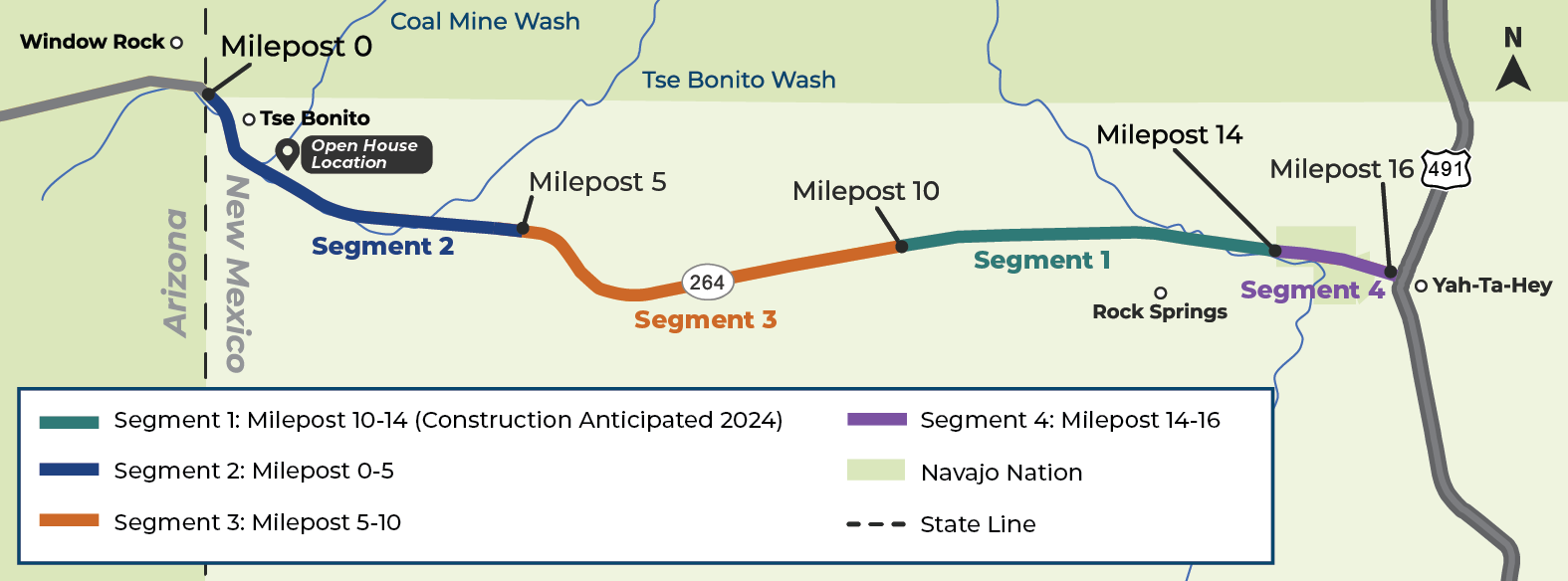
N.M. Highway 264 (NM 264) is a 16-mile highway that extends west to east from the New Mexico/Arizona state line (milepost 0.0) to the US 491 interchange near Yah-Ta-Hey (milepost 16.0) in McKinley County. It serves as a key corridor to the Navajo Nation, connecting communities to Window Rock, AZ, located five miles across the Arizona border. NM 264 also connects to US 491 eight miles north of Gallup. The NMDOT, in coordination with the Federal Highway Administration, is conducting the NM 264 Alignment Study (Study) and identifying why improvements to this highway are needed. The purpose of the Study is to document existing conditions and develop highway improvement alternatives for the corridor. Once the Study has been completed, improvements will be prioritized and as funding becomes available, work would be completed in phases.
PURPOSE AND NEED
The purpose of the project(s) would be to improve the roadway’s condition and life expectancy, improve drainage conditions, address substandard roadway geometry, add multimodal facilities, implement access management, and improve overall safety. The needs are based on deteriorated pavement conditions, which create a rough driving surface for vehicles. Additionally, existing drainage structures are in poor condition due to scour and/or significant sediment deposits, the roadway geometry is substandard, bicycle and pedestrian facilities don’t meet current standards, access management is lacking in urban areas, and the existing roadside guardrail is substandard.
FUNDING
Funding for the Study includes state funds through House Bill 2-2021 Legislative Session (HB2-21). Construction funding has been identified for a segment of NM 264 between MP 10 and MP 14 (Segment 1) under Control Number 6101221 and consists of state and federal dollars (e.g. HB2-21, Road Fund, STP Flex and STP Rural<5K). Segment 1 highway improvements under consideration include reconstruction of the existing four lanes, drainage improvements, and updating roadside barriers, signing, and pavement markings.

EXISTING STUDY AREA CONDITIONS
SEGMENT 1 – begins at the Arizona/New Mexico state line (milepost 0.0) and continues east to Hilltop Road (milepost 0.6). This segment passes through the town of Tse Bonito and is primarily urban in nature.
SEGMENT 2 – extends from Hilltop Road (milepost 0.6) east to the Cle Ki Drive intersection (milepost 15.5). This segment is approximately 14.9 miles long and is primarily rural in nature.
SEGMENT 3 – extends from the Cle Ki Drive intersection (milepost 15.5) east through the community of Yah-Ta-Hey to the US 491 interchange (milepost 16). This segment is 0.42 miles and is both rural and urban.
RECOMMENDED IMPROVEMENT ALTERNATIVES
Each alternative was evaluated based on purpose and need, traffic operations, safety, existing access and land use, right-of-way and environmental impacts, constructability, and construction cost. Based on the alternatives evaluation and community input received early in the study process, the following alternatives are recommended to advanced into the next phase:
SEGMENT 1 - URBAN SECTION (Milepost 0.0 to 0.6) - Tse Bonito
Eight urban alternatives were evaluated for this segment. The recommendation is for URBAN Alternative 3 with 4-travel lanes, a two-way left-turn lane (TWLTL), and bike lanes to move forward in the process.
Recommended URBAN Alternative 3 includes reconstruction of the existing roadway to include four 12-ft travel lanes, a 16-ft TWLTL, 6-ft bike lanes, curb and gutter, and 6-ft wide sidewalks. Other improvements would include improved crosswalk signal timing and the addition of lighting at the Alma Dr. signalized intersection. Urban Alternative 3 may be modified to incorporate 5-ft bike lanes, 3-ft bike buffers, and 11-ft travel lanes to improve bicycle safety and provide additional traffic-calming benefits.
SEGMENT 2 RURAL SECTION (Milepost 0.6 to 15.5)
The study team evaluated four alternatives for this segment. The recommendation is for RURAL Alternative 4 – 4-Travel Lanes with Striped Median to move forward in the process.
Recommended RURAL Alternative 4 includes reconstruction of the existing roadway to include four 12-ft travel lanes, an 8-ft flush median, 8-ft outside shoulders, and rumble strips. Other improvements would include updated signs and striping with left-turn lanes to adjacent properties.
SEGMENT 3 URBAN-RURAL SECTION (Mile Post 15.5 to 16.0) - Yah-Ta-Hey
The study team evaluated five alternatives for this segment. The recommended is URBAN-RURAL Alternative 3 with 4-travel lanes and a two-way left-turn lane (TWLTL).
Recommended URBAN-RURAL Alternative 3 includes reconstruction of the existing roadway to include four 12-ft travel lanes, 8-ft outside shoulders, a 16-ft two-way left-turn lane, and rumble strips. Other improvements would include updated signs and striping with left-turn lanes at major intersections.
PUBLIC INVOLVEMENT
THANK YOU FOR YOUR PARTICIPATION in the 2nd PUBLIC MEETING
hosted on May 17, 2023 at 6:00 P.M. (MDT)
NMDOT presented the improvement alternatives and recommendations developed for your review and input.
MEETING RESOURCES
Public Meeting #2 - Presentation (PDF)
May 17, 2023
Public Meeting #2 - Fact Sheet (PDF)
May 2023
Public Meeting #2 - Recorded Event
May 17, 2023
SHARE YOUR COMMENTS AND QUESTIONS WITH US!
We want to hear from you! Comments are being accepted from May 17, 2023, through June 16, 2023. Submit your comments by using the following methods:
Call: 505-357-7327
If no answer, please leave your name & best phone number and we will call you right back!
Mail: NM 264 Study
C/O Victoria Romejko, HDR Engineering
2155 Louisiana Blvd NE # 3000
Albuquerque, NM 87110
Email: NM264study@hdrinc.com
PREVIOUS ENGAGEMENT
The first public meeting for this study was hosted on August 23, 2022 followed by a 30-day comment period, which closed on September 22, 2022. Watch the recorded event, view the presentation, and explore the meeting summary. The meeting summary contains all the comments/questions received and responses provided.
Public Meeting #1 – Presentation (PDF)
August 23, 2022
August 23, 2022
Check back regularly for updates on how you can get involved!

PROJECT RESOURCES
Scoping Report for Segment 1, NM 264 MP 10 to MP 14
June 2021
Scoping Report (Segment 1) - Appendix A Drainage Exhibits
June 2021
Scoping Report (Segment 1) - Appendix B Hydrology
June 2021
Scoping Report (Segment 1) - Appendix C Hydraulics
June 2021
Scoping Report (Segment 1) - Appendix D Pavement Conditions Assessment Report
June 2021
NM 264 Alignment Study Public Involvement Plan
July 2022
NM 264 Alignment Study
Study Timeline
Spring/Summer 2022
• Establish the need for improvements
Summer/Fall 2022
• Virtual Public Meeting #1 – August 23, 2022
• Identify highway improvement alternatives
Fall/Winter 2022
• Evaluate improvement alternatives
• Prepare draft Alignment Study document
Spring 2023
• Virtual Public Meeting #2 – May 17, 2023
• Identify recommended alternative(s)
Summer 2023
• Select preferred alternative(s)
• Completion of NM 264 Alignment Study
Spring 2024
• Anticipated Start of Construction for Segment 1 (CN 6101221)
County
McKinley
District
District 6
STIP Number
Status
Study and Design
Contact
Priscilla Benavides, PDE
NMDOT Central Region Manager
505-250-8760