
Interstate 10/Arrowhead/University Phase 1-A/B Study
Milepost 141 to 144, Las Cruces, Dona Ana CountyNMDOT Control No. LC00280
STUDY OVERVIEW
WHERE IS THE STUDY AREA?
The New Mexico Department of Transportation (NMDOT) is conducting a study along Interstate 10 (I-10), spanning from the I-10/University Interchange (milepost 141) to the I-10/I-25 Interchange (milepost 144) on the west side of Las Cruces, New Mexico. The corridor within the study limits is a rural, divided four-lane roadway with 10-ft outside shoulders, 4-ft inside shoulders, and a depressed median with cable barrier. The posted speed limit on I-10 is 65 miles per hour.
WHAT IS THE GOAL FOR THE STUDY?
The goal of this study is to thoroughly assess the current condition and safety of the corridor. It will focus on identifying areas for improvement, including road conditions, ramps, lighting, drainage, and potential updates to the merge lane at the I-25 southbound to I-10 westbound interchange. The study will also evaluate the need for a six-lane roadway, better acceleration and deceleration lanes, and functional upgrades.
In addition, the study will explore options for a new interchange near the I-10/Arrowhead Interchange (around milepost 143) to improve access to New Mexico State University’s Arrowhead Park and surrounding developments. This will include examining economic growth potential and the impact of new infrastructure along the interstate. The final recommendations will be outlined in a combined Phase I-A/B Report.
WHERE ARE WE AND WHAT ARE THE NEXT STEPS?
The study team is currently gathering data on existing conditions and developing some preliminary improvement alternatives. This fall, the team plans to present the findings to the community to gather feedback and help refine the proposed options. Once public input is incorporated and the alternatives will be further analyzed, a prioritization plan will be created. This plan will guide phased implementation as funding becomes available.
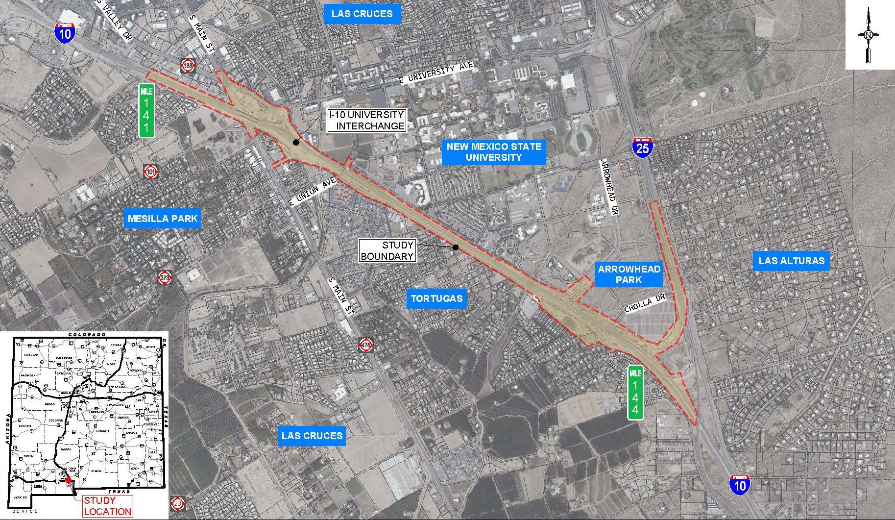
Figure 1. Study Area Vicinity Map (click to enlarge).
STUDY RESOURCES
BACKGROUND HISTORY
Las Cruces was officially founded in 1849, following the Mexican-American War and the U.S. acquisition of southern New Mexico. The U.S. Army surveyed the land, laid out 84 blocks, and distributed plots to incoming settlers. The city’s name, “Las Cruces,” meaning “the crosses,” is believed to come from makeshift grave markers for soldiers and travelers who died in the area.
The arrival of the Atchison, Topeka & Santa Fe Railroad in 1881 boosted growth, followed by the founding of the New Mexico College of Agriculture and Mechanic Arts (now New Mexico State University) in 1888. Las Cruces was incorporated in 1907, and by 1940, the population had reached 9,000.
During World War II, the nearby Tularosa Basin became a key military testing ground, including the Trinity Site, where the first atomic bomb was detonated in 1945. In the 1950s, I-10 was built along the path of old U.S. Route 80, linking Las Cruces with El Paso and supporting continued growth in the region.
PUBLIC INVOLVEMENT
Thank you for joining us!
The New Mexico Department of Transportation (NMDOT) will host a virtual public meeting this summer/fall to share project updates, gather input, and help shape the preliminary alternatives under development.
We invite you to join the conversation and play a key role in guiding decisions to make I-10 safer and more efficient for everyone.
Your feedback matters. Stay tuned for more ways to get involved!
Your voice matters!
Public input is a key part of the NMDOT Location Study process. While funding for future improvements hasn’t been secured yet, this study will help identify the most important issues along the corridor and guide efforts to prioritize and seek funding.
In this first phase of outreach, we’re focused on introducing the study, hearing from people who use the corridor, and learning more about the real-world challenges facing all users.
Later in the process, we’ll come back to the public to share what we’ve learned, present possible improvement options, and gather feedback on the preferred alternative and how improvements could be phased over time.
I-10/Arrowhead/University Phase 1-A/B Study
Project Timeline
Summer 2023-2024
- Collect existing condition data
- Establish the need for improvements
Summer 2025
• Develop preliminary alternatives
Summer/Fall 2025
• Public Event #1 – October 2025
Winter 2025
• Evaluate improvement alternatives in detail
• Prepare draft Corridor Study document
Spring 2026
• Public Event #2
• Identify recommended alternative(s) and develop prioritization plan
Summer 2026
• Finalize Phase 1-A/B Study